 American Imperialism
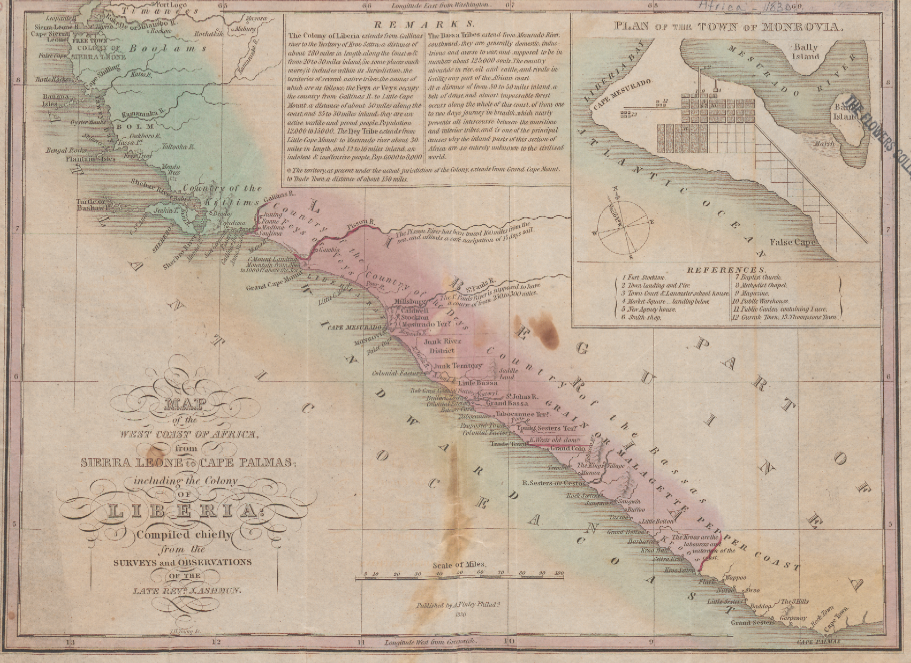
Anthony Finley’s map of the private colony of Liberia provides a glimpse of early American imperialism as revealed by an active interest in geography. By one 1821 American account in The Literary and scientific repository, and critical review, an American “had vastly more geographical feeling than the European.” “The thoughts of the European farmer,” the same writer noted superiorly, “range within a circle of twenty miles diameter. The ideas of the American planter familiarly traverse the wide extent between the shores of the Atlantic and Pacific oceans.” The large size of America, it was held, led to a greater interest in geography. This “geographical feeling” was channeled into a brand of imperialism that justified expansion and conquest through the promotion of virtue and democracy. Exemplifying this mindset was the American Society for Colonizing the Free People of Color of the United States, proprietors of the colony of Liberia.
Finley’s map was based on the surveys of Society agent Jehudi Ashmun, and is replete with details that touch upon the many different motives behind both the colony and this American outpost in Africa. Ashmun was a devoted proponent of Liberia, and expended a great deal of energy attempting to convince the American Colonization Society’s board of directors back in America that Liberia was ripe for greater agricultural development and trade investment. Accordingly, in the map based off of his surveys, great emphasis is placed on the organizational and civilizing processes already underway in the colony, including an inset map of the capitol of Monrovia labeling the location of churches and commercial buildings in the city. Even the place names on the map depict the process of “civilizing” the region. The core of the colony is dotted with names such as Millsburg, Stockton, and Monrovia, but as you travel towards the edges of the colony the names become progressively more African, with villages labeled Teembo, Tassoo and Settra Kroo. Finley has even included the location of a “proposed town” in the middle ground between the two extremes. According to this map, in 1830 Liberia was poised for expansion.
Purposes Behind the Map
That religion and commerce should be the two main points of interest in Liberia mirrored the dual mission of the Society, and of American imperial interests: it was both a means of spreading American moral superiority, and of expanding American commercial interests abroad. The map itself provided a snapshot of a burgeoning and successful colony abroad. When published, it supported the Society’s moral mission by appearing in their Thirteenth Annual Report of 1830, but was also placed by Anthony Finley in his popular annual atlas, where its ethnographic descriptions and precise explanation of the colony’s size both asserted and publicized America’s imperial presence to a broader audience.
Sources
American Colonization Society. “The thirteenth annual report of the American Society for Colonizing the Free People of Colour of the United States: with an appendix.” Washington [D.C.], 1830. Slavery and Anti-Slavery. Gale Digital Collections. Web.
Ashmun, J. (Jehudi). “Map of the west coast of Africa from Sierra Leone to Cape Palmas: including the colony of Liberia.” Philad[elphi]a, 1831. Slavery and Anti-Slavery. Gale Digital Collections. Web.
Bruckner, Martin. “Literacy for Empire: Geography, Education, and the Aesthetic of Territoriality.” In The Geographic Revolution in Early America. Chapel Hill, NC: University of North Carolina Press, 2006. Print.
Finley, Anthony. “Title Page: New general atlas.” Philadelphia: Anthony Finley, 1831. David Rumsey Historical Map Collection. Print.
Gardner, Charles K. “Article X – America and her Resources….[Review, July 1820].” In The Literary and scientific repository, and critical review, 2 no.3 (1821). New-York: Wiley and Halsted. HathiTrust Digital Library. Web.
Gurley, Ralph Randolph. “Life of Jehudi Ashmun, late colonial agent in Liberia: with an appendix containing extracts from his journal and other writings: with a brief sketch of the life of the Rev. Lott Cary.” Washington, 1835. The Making Of The Modern World. Web.
“Jehudi Ashmun Painted by N. Jocelyn. Engd. by S. S. Jocelyn.” Images from the History of Medicine. National Library of Medicine. Web.
Ristow, Walter W. American Maps and Mapmakers: Commercial Cartography in the Nineteenth Century. Detroit: Wayne State University Press, 1985. Print.
Staudenraus, P. J. The African colonization movement, 1816-1865. New York: Columbia University Press, 1961. Print.