 The Berlin West Africa Conference
By the late nineteenth century the colonization of Africa had reached its peak, with countries such as England, France, Portugal, and Italy making claims on the continent, and King Leopold II of Belgium working to establish a ‘free trade zone’ in central Africa with the intention of gaining a personal colony. In 1884 a conference was hosted in Berlin and attended by all major colonial powers, with the main goal of deciding both the validity of King Leopold’s Congo Free State and the sovereignty of the Congo and Niger rivers. Importantly, this conference also further regulated “new occupations” made on the coast of Africa by European powers, establishing a doctrine of “effective occupation”. Under these guidelines, imperial powers were “to insure the establishment of authority in the regions occupied by them.” The implementation of these guidelines compelled European powers to assert themselves in Africa in a more active and aggressive manner moving into the twentieth century.
Justus Perthes and Hermann Habenicht
The Justus Perthes publishing house, founded in Gotha in 1785, rose to prominence over the course of the mid-nineteenth century. Hermann Habenicht joined the company in 1879, studying under famed cartographer August Petermann. Habenicht gained a reputation for excellence, pouring over mountains of sources that he later compiled into accurate and beautifully drawn maps. Before the establishment of an official imperial cartography bureau, the cartographers at Justus Perthes worked to prove their prowess at producing colonial maps. However, Habenicht effectively removed the company from involvement in official German colonial cartography in 1891, when he insulted the work being done by cartographers in the capital of Berlin. While Perthes continued to develop and produce maps that were helpful to the colonial administration, it is important to note that these maps were not funded by the government and thus subject to business risks. The Spezial-karte is an example of such a map.
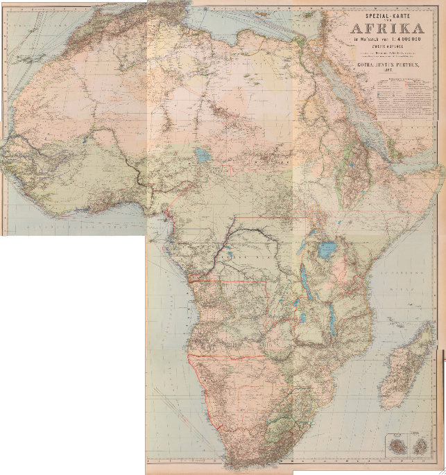
Spezial-karte: Development and Production
The Spezial-karte von Afrika was developed to commemorate the centennial of Justus Perthes and celebrate the Berlin Conference. In many ways, this conference marked Germany’s rising colonial ambitions and emergence as an overseas power. The decision by Habenicht to produce a map of Africa was aided in part by the high volume of sources available to cartographers, as well as the high level of public interest in Africa. Due to the fact that the production of this map was not subsidized by government sources, it was produced with profitability in mind. This large, ten-piece wall map was issued in installments, like many other large atlases of the period, in order to aid development and production. The Spezial-karte was updated and reissued on three occasions between 1885 and 1892. The map in the exhibit represents the second edition published in 1887.
In developing the Spezial-karte, the cartographers of Justus Perthes were in the unique position of selecting from a wide range and variety of sources, ranging from official surveys, geographical journals, explorers itineraries, and other ad-hoc material. Habenicht developed a hierarchy to guide the handling of these sources that addressed, in order of decreasing importance, sea charts, official surveys, explorers’ itineraries, and finally extrapolations of information gained from indigenous peoples. Though a German publishing company, the cartographers of Perthes compiled sources from across Europe, including such famous explorers as Englishman David Livingstone and the American Henry Morton Stanley. However, the emphasis placed on Western sources and discounting of indigenous reports did lead to some interesting features, such as the inclusion of the non-existent Mountains of Kong.
Sources
Adams, Cyrus. “Maps and Map-Making.” Bulletin of the American Geographical Society 44.3 (1912): 194-201. JSTOR. Web.
Bodenstein, Wulf. “Hermann Habenicht’s Spezialkarte von Afrika — A Unique Cartographic Record of African Exploration 1885–1892.” Tarrae Incognitae 44 (September 2012): 139-162. Web. <https://dx.doi.org/10.1179/0082288412Z.00000000010>.
Chamberlain, M.E. The Scramble for Africa. Harlow: Pearson Education Limited, 2010. Print.
Föster, Stig, Wolfgang J. Mommsen and Ronald Robinson, eds. Bismarck, Europe, and Africa. London: Oxford University Press, 1988. Print.
Hafeneder, Rudolf. “German Colonial Cartography: 1884-1919.” PhD. Diss., Bundeswehr University Munich, 2008. Print.
Hinrichsen, Adolf. Das literarische Deutschland. 2nd ed. Berlin: C.F. Steinacker, 1891. Print.
Scharfe, Wolfgang. “German Atlas Development during the Nineteenth Century.” In Images of the World: the Atlas Through History. Eds. John A. Wolter and Ronald E. Grim. New York: McGraw-Hill, 1997. 207-232. Print.