 J.B.B.d’Anville
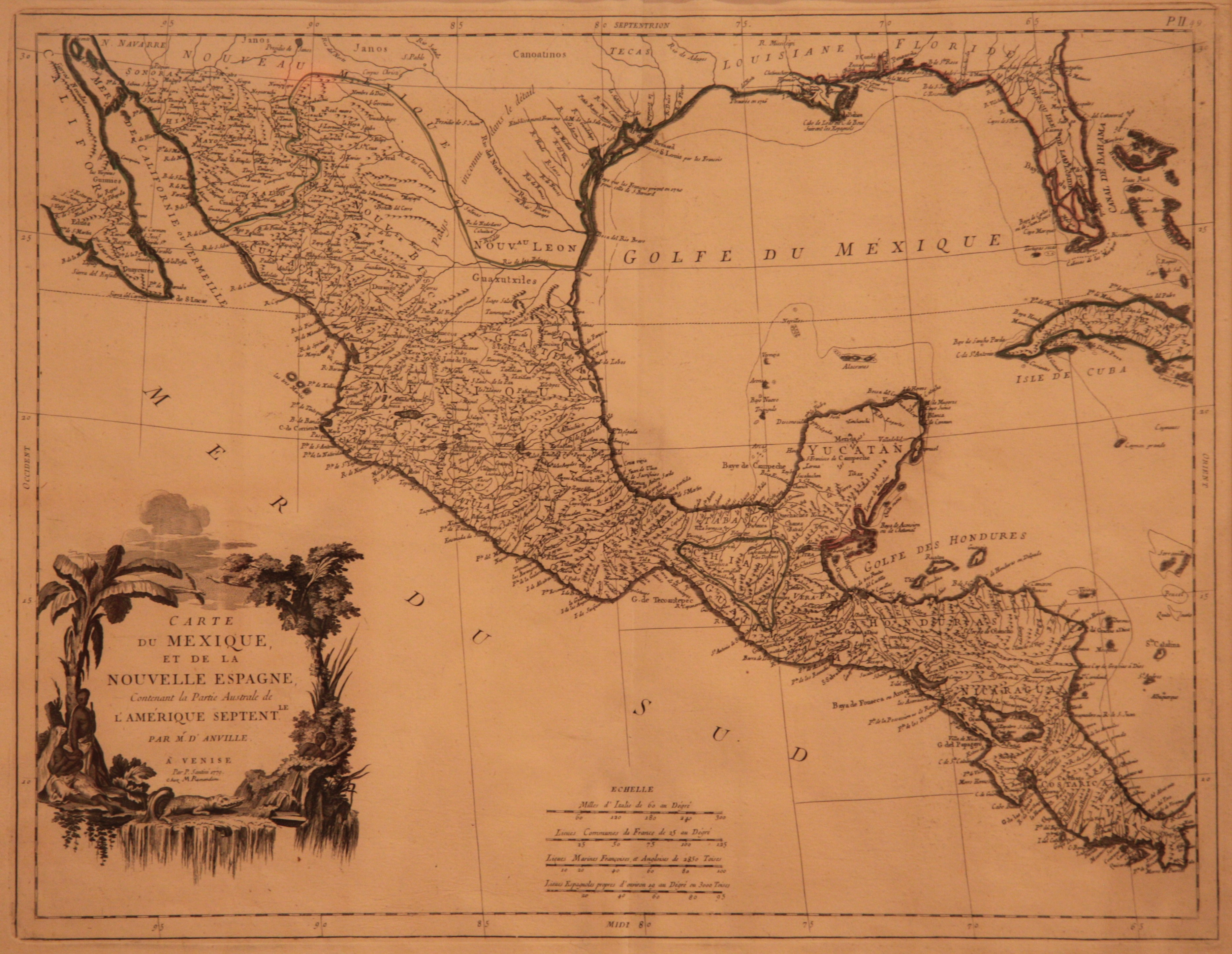
Jean-Baptiste Bourguignon d’Anville (1697-1782), a Paris native, began his career around 1718 working for Louis Du Four de Longuerue, a specialist in the classics and oriental languages. By 1719, d’Anville was appointed as geography tutor to King Louis XV. Furthermore, d’Anville had a strong patronage relationship with the Orleans family. D’Anville produced more than 200 maps and gathered a huge map collection, which was turned into the Bibliotheque nationale de France after his death.
J.B.B. d’Anville’s Mapmaking Methodology
First d’Anville would gather a exhaustive amount of sources for the geography of the region in question. He used classical texts, resources of his library, and oral sources. Once he had amassed a suitable amount of source material, he would then turn to the actual drafting process. D’Anville used large sheets of thick white paper that had been selected for its durability and ability to withstand erasing and scraping. He would make his initial drawings with lead pencil so that mistakes could be easily erased. The strength of the line reflected d’Anville’s certainty about the features he was sketching in. Usually, the scale of these preliminary drafts were larger than the scale of the finished maps, which allowed him to work more easily on the most minute details. D’Anville would then turn to revisions, comparing his rough maps to his data to check if what he had drawn was correct. He often asked travelers and ambassadors to correct his maps.
With the original drawing complete, the map would be turned over to engravers for actual production. D’Anville gave his engravers no license for any stylistic variation. He checked every proof himself and treated them to equal study. For all his work, d’Anville would also write a long essay or dissertation in which he identified his sources, explained his general approach, highlighted his method of analysis, and justified his work.
Remondini Publishing Firm
Giovanni Antonio Remondini, originally from Padua, established the Remondini Publishing Firm in 1657 in a house on the best square in Bassano, Venice. The firm printed books, booklets, handbills, pamphlets, and prints. By 1715, the firm had 12 printing presses, which gave the firm a competitive position in the international market. This huge business capital as well privileges granted by the Venetian State led to its growth. By 1773, the Remondini firm was regarded as one of the greatest in Europe. The firm had 1,000 employees, 54 press machines, of which 32 were dedicated to the production of prints.
Sources
Biggs, Michael. “Putting the State on the Map: Cartography, Territory, and European State Formation.” Comparative Studies in Society and History 41.2 (1999): 374-405. JSTOR. Web.
Boschloo, Anton W. A. The Prints of the Remondinis : An Attempt to Reconstruct an Eighteenth-Century World of Pictures. Amsterdam: Amsterdam University Press, 1998. Print.
Craib, Raymond B. “Cartography and Power in the Conquest and Creation of New Spain.” Latin American Research Review 35.1 (2000): 7-36. Web.
Donahue-Wallace, Kelly. “Colonial Cities.” In Art and Architecture of Viceregal Latin America, 1521-1821. Albuquerque: University of New Mexico Press, 2008. 72. Print.
Dym, Jordana, and Karl Offen, eds. Mapping Latin America: A Cartographic Reader. Chicago: The University of Chicago Press, 2011. Print.
Godlewska, Anne. Geography Unbound: French Geographic Science from Cassini to Humboldt. Chicago: University of Chicago Press, 1999. Print.
Haguet, Lucile. “J.-B. d’Anville as Armchair Mapmaker: The Impact of Production Contexts on His Work.” Imago Mundi 63.1 (2011): 88-105. Web.
Hardoy, Jorge E. “Urban Cartography in Latin America during the Colonial Period.” Latin American Research Review 18.3 (1983): 127.134. JSTOR. Web.
Heinz, Markus. “A Programme for Map Publishing: The Homann Firm in the Eighteenth Century.” Imago Mundi 49 (1997): 104. Web.
Kinsbruner, Jay. The Colonial Spanish-American City. Austin: University of Texas Press, 2005. Print.
“De L’Isle Family.” Geographicus. Web. <https://www.geographicus.com/mm5/merchant.mvc?Screen=CAD&Product_Code=delisle>.
Mundy, Barbara E. The Mapping of New Spain. Chicago: The University of Chicago Press, 1996. Print.
Padrón, Ricardo, 1967-. The Spacious Word: Cartography, Literature, and Empire in Early Modern Spain. Chicago: University of Chicago Press, 2004. Print.
Petto, Christine Marie,. When France was King of Cartography : The Patronage and Production of Maps in Early Modern France. Lanham: Lexington Books, 2007. Print.
Rama, Angel. The Lettered City. Ed. John Charles Chasteen. Durham: Duke University Press, 1996. Print.
Socolow, Susan Migden, and Lyman L. Johnson. “Urbanization in Colonial Latin America.” Journal of Urban History 8.1 (1981): 27-59. SAGE Publications. Web.
Tooley, R. V. Title Pages: From 16th to 19th Century. Ed. Map Collectors’ Circle. London: Map Collectors’ Circle, 1975. Print.
“Typus Geographicus: Chili a Paraguay Freti Magellanici.” Nuremberg: Hormann Erben, 1733. University of Washington Libraries. <https://content.lib.washington.edu/u?/maps,111>.
Wroth, Lawrance C. “Alonso De Ovalle’s Large Map of Chile, 1646.” Imago Mundi 14 (1959): 90-95. Web.