 A Manuscript Map
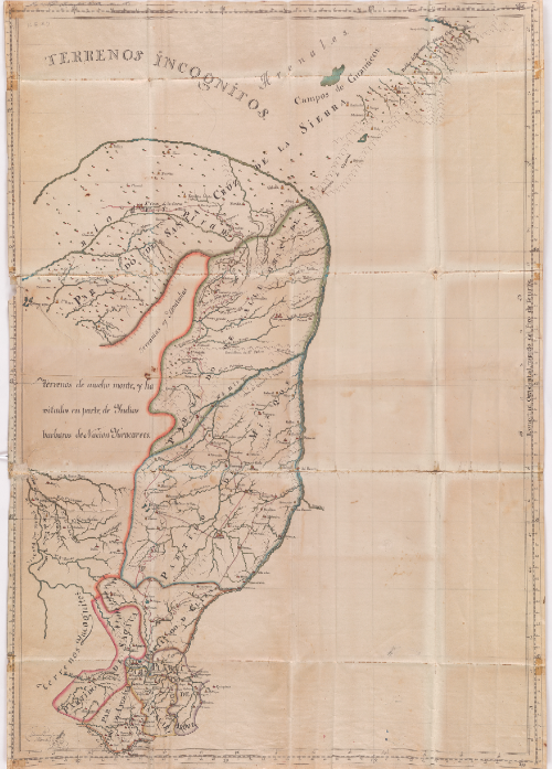
This map is different from many maps in the exhibition because it is a manuscript map; it is hand drawn as opposed to printed from an engraving. Little is known of the mapmaker, Manuel Pantosa y Moreno, who signed the piece; however, his map was mentioned in a geographic report by Francisco de Viedma, a Spanish explorer and governor of the Patagonian Coast and surrounding areas. Viedma was governor of Cochachamba, a small colonial town that is mentioned in the document accompanying this piece.
Interpreting the Map
The mapped area, now part of Bolivia, is divided into eight partitions. Four of these partitions made up a district within one Catholic Mission’s responsibility, while the other four were individually controlled by separate Missions. These areas were mostly agricultural lands that were used to support the workers of silver mines. Beyond the borders established by the map is the label “barbarous indians,” who are described in Viedma’s report as the Raches and Yucaracaree Nations. While the term “barbarous” likely derives from the fear Spanish inhabitants in Santa Cruz de la Sierra had for the natives, the ”Indians” mentioned in the report are described simply as people who lack Catholicism.
Blank Spaces and Stripping Space of Familiarity
What is fascinating about this map is the proliferation of blank spaces. The empty piece of land in the center strips the map of the familiarity that modern society has with the concrete images of geography and nations that maps have created over the centuries. If the viewer was not familiar with the Spanish title, Santa Cruz de la Sierra, this territory could just as well have been a map of any rural area, let alone Bolivia. The empty spaces leave the modern viewer with a level of discomfort similar to that which the nineteenth century user would have felt wondering what was beyond the colored lines in the blank spaces of the page.
Sources
Dym, Jordana and Karl Offen, eds. Mapping Latin America: A Cartographic Reader. Chicago: University of Chicago Press, 2011. Print.
Hepple , Leslie W. “South American Heartland: The Charcas, Latin American Geopolitics and Global Strategies.” The Geographic Journal 170 (2004): 291-384. JSTOR. Web.
Ristow, Walter W. A La Carte; selected papers on maps and atlases. Washington D.C.: Library of Congress, 1972. Print.
Smith, Monica L. . “Networks, Territories, and the Cartography of Ancient States.” Annals of the Association of American Geographers 95 (2005): 832-849. JSTOR. Web.
Viedma, Francisco. “Descripción Geográfica y Estadística de la Provincia de Santo Cruz de la Sierra.” Biblioteca Virtual Universal. Web. <https://www.biblioteca.org.ar/libros/130469.pdf>.