“A piscatorial El Dorado”
Today, the small island called Newfoundland is a peripheral part of the Canadian state. But this island was a center of British trade for roughly 100 years before any of the lower American colonies were established. In fact, Newfoundland played a large role in inspiring further trade and settlement in the lower American colonies.[1] On more than one occasion, fish from the Newfoundland fisheries were sent south to save Raleigh’s starving colonists in Virginia. For this and more, Prowse calls Newfoundland “the parent colony, a meagre and haggard kind of mother” to the rest of Britain’s colonies.[2]
The size and importance of the fishing trade in Newfoundland cannot be overstated. The fisheries there had become a key component of Britain’s global economy by the time lower American colonies were a
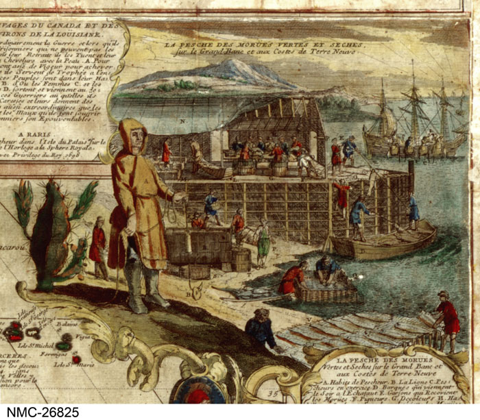
ble to produce anything. By 1630, the fishing trade in Newfoundland was easily the most important American investment for the British. The strong association between the English and their fishing was not only recognized within England; Johan De Witt, the Dutch Grand Pensionary, wrote that “The navy of England became formidable by the discovery of the inexpressible rich fishing bank of Newfoundland.”[3] The defense and maintenance of the fishing economy in Newfoundland was thus of the utmost importance for England’s continued military strength. Raleigh declared that a successful attack against the fleet of Newfoundland would be “the greatest misfortune that could befall England.”[4] The wealth and human capital involved in the English trade was indeed substantial. In 1615, Richard Whitbourne estimated there were 250 English vessels carrying 5,000 men and catching fish worth an astounding £120,000. Prowse encapsulates all of this when he says that the discovery of Newfoundland “was a veritable God-send – a piscatorial El Dorado.” For, in this age, “codfish was gold.”[5] The above image depicts a cod fishing station from the end of the 17th century. It was copied and reproduced along side a map of Newfoundland by Herman Moll, the famous maker of maps in England, in his 1715 A New and Exact Map of the Dominions of the King of Great Britain.
All of this is to affirm the centrality and importance of Newfoundland to the fledgling British Empire. But, as is often the case, the British were not the first to capitalize on Newfoundland’s bounty. French fishers were the first to establish a consistent trade there. They had the largest fishing fleet in Newfoundland until around 1580, and traded more in Newfoundland than the British well into the 17th century.[6] The French lawyer Lescarbot records the tale of a French fishing captain in the late 16th century who “took, every day, fifty crownes worth of fish, and that his voyage would be worth £1000. He paid wages to sixteen men and his vessel was of eighty tunnes and would carry 100,000 dry fishes.”[7] Again, the French flourish in Newfoundland came early. It was reported that in 1541-1542 there were a sizeable 60 French ships fishing in Newfoundland.[8]
The same is true of Spanish Basque fisherman. Tensions between the English and Spanish were on the rise for much of the 16th century and this strained the relationship between English and Spanish fishing outfits. Nonetheless, different groups of Spanish fisherman had an astounding presence: it is reported that during Phillip II’s reign (1554-1598) roughly 200 ships and 6,000 men were employed in the Newfoundland fishery.[9] By the end of the 16th century, the Spanish and Portuguese fisheries were mostly defunct and the remaining trade was divided evenly between French and British outfits.
In all cases, it must be understood that fishing in Newfoundland was primarily migratory. That is, most fishing outfits took a single voyage to Newfoundland in the spring and fished all summer, returning to Europe with their catch in the fall. Thus, the fisheries were relatively loose institutions which, it will become clear, clashed with the intentions of the earliest colonists.
Newfoundland does not figure prominently in modern discussions of European empire-making and colonization. An important part of this case study has been to discover that Newfoundland was not a backwater, but a key center of trade for the European powers.
Changing Hands, Changing Sovereigns: 1600-1630
The fishery at Newfoundland would not see a significant decline in commerce until the late 18th century. The situation on land, however, was different. Though they were the larger players in Newfoundland, the French did not make any major land claims on the island until after the mid-1600’s. The English began making claims well before that. This case study focuses on two royal charters, the Charter for the London and Bristol Company (1610) and the Charter for the colony of Avalon (1623). These royal charters are of two different types, the first a corporate charter and the second a personal proprietary charter. These charters alone do not tell the entire story of land claims in this period; there were a series of private land sales that occurred in between and after the issuance of these charters. Taken together, these show an interesting and fluid understanding of sovereignty among the English.
The first charter was issued in 1610 by James I. It establishes the London and Bristol Company, commonly called the Newfoundland Company and its board. It grants the company control over the natural resources (land, rivers, hunting, and fishing) on the island in two ways. First, it outlines an area south of the parallel line running through Bonavista (“Bomviste,” in the charter) and east of the meridian line passing through the cape known as Cape St. Mary’s or Cape Sancta-Maria:

This essentially outlines what we now call the Avalon Peninsula, which was the center of English fishing and would henceforth become the focus of English settlement.
Interestingly, though, the charter also includes a catch-all grant of any land “commonly called Newfoundland” between 46 and 52 degrees of northerly latitude. There was no eastern or western boundary specified. On the modern map that looks like this:

The grant also include any sea or islands within 10 leagues of the shores of the territory specified above.
Fish are the elephant in the room in this charter. Fishing was the primary reason for continued English interest in Newfoundland. The charter’s focus on the Avalon Peninsula shows that part of the new company’s role would be to continue the vitality of the fishing trade there. However, words relating to “fish” or “fishing” occur a meager nine times in the charter, and the remarks on fishing are made only in passing. The charter does establish the company’s authority in the English fisheries, and it clarifies how taxes and import fees are to be levied with regards to fishing. But in practice, this charter was the beginning of English settlement and colonization. With the English understanding of territorial possession firmly rooted in land development, this movement toward land claims is not unexpected. This charter established England’s second overseas plantation (the first being in Virginia). (56) The company hoped that permanent settlements would allow them to better control the fisheries over time by making legitimate territorial claims and the powers that usually went with them.
A Bristol merchant named John Guy was the company’s first agent in Newfoundland. He was instructed to fortify and expand the settlement at Cupid’s Cove in Conception Bay. By 1615 the colony was becoming dysfunctional thanks to spats with migratory fisherman and a lack of positive interaction with native tribes like the Beothuk. Guy fled Newfoundland in 1615, and John Mason assumed leadership of the foundering colony which existed at least in name until 1621, when Mason took up other exploits in New England. John Mason and his map of Newfoundland will be especially important in the next section.
Most relevant to this case study is what happened beginning in 1616. The board of the company, discouraged by the colony’s limited success, decided to liquidate much of its territory on the Avalon Peninsula. The company sold a large section of the peninsula, south of a line running through Calvert Bay, to the Welsh lawyer William Vaughan. Vaughan’s possession after 1616 is all land below the red line:

The section north of that was sold in portions to George Calvert, Lord Baltimore. His possessions are shown here in between the blue lines:

This transactions are interesting for the change in sovereignty which they expose. Originally, this land was chartered by the king. It was the king’s prerogative to grant this otherwise un-granted land to the company for the purpose of generating revenue. However, when the company became defunct, the land did not default to the king’s authority, it was firmly the right of the company to sell-off its land. In this way, the sovereign over this territory decidedly changed from the English monarch to the English company enumerated by that monarch.
The same standard held true when Richard Vaughan’s colonization effort fell through and he abandoned it in 1619 and liquidated it between 1619 and 1621. He sold a narrow strip of it between the ports of Fermeuse and Renews to Henry Cary, at this point Lord Deputy of Ireland. He sold the rest of his possessions north of this strip to Calvert. Cary’s strip (light blue) was here called “South Falkland,” as “North Falkland” was a larger possession of his on the main part of the island. Calvert began to establish a full colony at Ferryland in 1621.

In 1623 came another charter from James I, establishing the colony of Avalon under the proprietorship of George Calvert. This charter essentially gave royal sanction for a colony made up of land already possessed by Calvert (between the two blue lines on the map above). He maintained this colony until 1629, when he left to pursue his other grants in the Chesapeake.
With each step of the exchange, there was a fluid transition between sovereign English powers. This land was originally granted under the authority of the monarch to a corporate entity. When the company did not achieve long-term success, it was the corporate sovereign’s prerogative to sell-off its possessions to individual proprietors. Those individual proprietors were sovereigns empowered to trade their property with other proprietors. In the end, George Calvert was granted a royal charter as a sanction of property already attained by private purchase. In this way, the fluidity of sovereignty among English entities came full circle.
There are two interpretations of this. On the one hand, it might be fair to say that the crown never truly relinquished control over these claims. The king was able to step back in 13 years after the original charter to re-charter what amounted to a chunk of the same territory. This territory was purchased and owned by an individual proprietor, but there was still some authority for the king to charter it. Alternatively, it could be said that the charter of 1623 was necessary or important precisely because the crown had relinquished its authority and wanted or needed to have it reinstated. The financial benefit for the crown (in the form of taxes and import fees) was not insignificant, especially as English fishing was in one of its most profitable swings. A legitimate loss of royal control – or at least royal involvement – may have required a legitimate re-instatement.
In any case, the Avalon Peninsula of Newfoundland is remarkable for the flexible agents of sovereignty among different English entities and
Self image: Mason’s map
The English adventurer John Mason was mentioned above for his brief stint as the Newfoundland Company’s agent. For this case study, he is most interesting for his map and his correspondence regarding the geography of the island.
His map, first made around 1617, is the first English map of the island. Earlier maps printed in England relied exclusively upon French and Spanish data. Mason, though also considering this earlier data, included information gathered from his own substantial navigation around the island. This map is draw with the north side of the island on the bottom of the map.

Mason’s map is impressive for its relative accuracy; his depiction of the Avalon Peninsula is especially on point. This map is not, however, purely factual. In its portrayal of Newfoundland it betrays the great truth about English presence there – the English were almost exclusively interested in the Avalon Peninsula. This is not news; it should be relatively clear from the 1610 charter and its unique focus there. This English state of mind is made manifest in Mason’s map. When placed over the modern globe, one can easily see the lack of proper proportion. The Avalon Peninsula (outlined in red), made to line up on the modern globe, leaves the rest of the island woefully undersized on Mason’s map:

This map, published and accepted as an objective and factual document, is fundamentally shaped by English consciousness of the region. Simply put, the areas in which the English had settled and traded more thoroughly are proportionately larger on the map. In a very real way, the relative importance of the Avalon Peninsula to the English is depicted by its relative size. This, though not exactly intentional, is a prime example of the subjectivity involved in the cartography of the period.
Notes (see “Resources” page for complete reference bibliography):
[1] Prowse, 88
[2] Prowse, xxiv
[3] Prowse, 17
[4] Prowse, xxiii – Hatfield MS
[5] Prowse, 18
[6] Prowse, 49, also https://www.heritage.nf.ca/exploration/16fishery.html
[7] Marc Lescarbot, Nova Francia, London: 1609, p. 129; also quoted in Prowse p. 20
[8] Prowse, 49
[9] Prowse, 48