“Wisdom. Justice. Moderation.”
Why was the founding of the Georgia colony important in regards to British sovereignty? The answer is threefold. Firstly, the language in the charter used to identify the land claimed speaks to the ambiguous nature of colonial settlements. Namely, the “Alatamaha River,” as it is called in the 1732 charter, is created from the joining of two feeding rivers, the Ocmulgee and the Oconee rivers. James Oglethorpe and the other founders of Georgia chose to include the Ocmulgee as an extension of the Altamaha, even though these two rivers were often referred to as separate in contemporary documents. The only reason for this discrepancy would be for the founders to be able to claim more of the land to the northwest, which was already moderately populated, mostly by Native American tribes. Using river names in this way reflects, on a larger scale, the many efforts on behalf of colonial founders to alter the existing territory for the British Crown’s benefit. Given that the crown authorized all charters, it would not have been hard to convince a far-away member of Parliament or even the King himself that the two rivers were actually just one river, and Georgia should claim both as its southern border.
The second important point has to do with the nature of Georgia’s colony specifically. While many other colonies were founded by companies or for economic purposes, Georgia was founded for two main purposes—protection and containment. The new colony would be a buffer to the other, more established colonies of the new world, and its inhabitants would be those sentenced to work in the colonies, namely debtors and criminals. Having a region filled with people that could be forced to fight invading forces seemed ideal to the colonists as well as the government of Great Britain.
The third point stems from a development of the second. Although Georgia was intended to serve as a buffer from the other colonies, beginning with South Carolina, the legislative bodies of these two southern colonies often fought amongst themselves, even with a looming foreign threat.
Forming the Colony

Georgia’s original boundaries, as defined by its charter, was all of the land, “which lies from the most northern part of a stream or river there, commonly called the Savannah, all along the sea coast to the southward, unto the most southern stream of a certain other great water or river called the Alatamaha, and westerly from the heads of the said rivers respectively, in direct lines to the south seas”.[1] Above is a screenshot of what 1732 Georgia would’ve looked like as defined by the charter. However, due to numerous factors that led to the English settling only a small portion of this grant.
Georgia’s original southern boundary, in order to prevent tensions with the Spanish, was placed much farther to the north than the original border of Carolina. The land in between Georgia and Florida then became a sort of European no man’s land (the Creek Confederation and other Native Americans took advantage of the lack of European settlement to move into this area).[2] The Creeks were a domineering force for much of Georgia’s early life as a colony; although they swore allegiance to Great Britain they were hostile to any westward expansion of the aforementioned colony.[3] For this reason European Georgia controlled little of what it had claimed in its charter, and was brought to the brink of war with the Native American tribes at many a time.
Reshaping the Colony
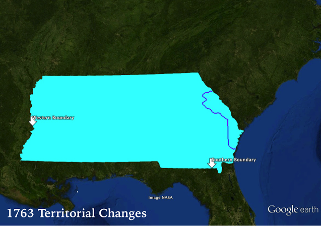
While the land in between Georgia and Florida was not officially settled by either colony, it was full of troops from either side. Most British colonial regiments stationed in this area were from South Carolina, which would generate conflict later on.[4] Forays into this region were excused as attempts to rid the country of outlaws, who saw this no man’s land as a chance to escape justice. This all changed after the end of the seven year’s war. Above is what Georgia would’ve looked like at the end of 1763. With the signing of the Treaty of Paris came new boundaries for all of the English colonies. In recognition of French claims to Louisiana, Georgia’s western boundary was shortened from the South Sea (or Pacific Ocean) to the Mississippi River.[5] However, nowhere in the treaty was Georgia’s southern boundary changed. With Florida now under British control and the need for a bulwark between it and the English colonies now gone, South Carolina plotted to take back some of its former territory. The government of South Carolina started claiming land south of the Altamaha River by selling it in parcels to South Carolina planters soon after the colonies received news of the Spanish cession; its main defenses in this action were that the land should be ceded to them through the Carolina Charter of 1663 and that they already had a strong troop presence in the region.[6] This, of course, created much conflict with Georgia, which retaliated by claiming (among other things) that South Carolina should not own any part of the land, for they did not have the tact to be able to put it to much use. This bickering continued until the land issue was finally settled by the Royal Proclamation of October 7, 1763.[7] This paper formally set the boundary of Georgia as the one it has today. However, one has to take into consideration that much of Georgia was still under Native American control. A month after the proclamation, the true boundary line between Creek and European territory in Georgia was established at the Southern Indian District Congress.[8]
Throughout its various border disputes and amendments, Georgia served as a unique type of colony as buffer against foreign invasions. With Georgia, the conflicts between English and other populations—whether European or Indigenous—become evident, as do the conflicts amongst the English settlers themselves. The amendments made to the Georgia charter also exemplify the nature of charters as malleable documents as opposed to static decrees of sovereignty.
[1] “The Georgia Charter” from The Federal and State Constitutions Colonial Charters, and Other Organic Laws of the States, Territories, and Colonies Now or Heretofore Forming the United States of America Compiled and Edited Under the Act of Congress of June 30, 1906 by Francis Newton Thorpe (Washington, DC : Government Printing Office, 1909.)
[2] George Gilman Smith, The story of Georgia and the Georgia people, 1732 to 1860. (Macon, GA: G.G. Smith, 1900). 150
[3] Louis DeVorsey, “Indian Boundaries in Colonial Georgia.” (The Georgia Historical Quarterly 54, no. 1 (1970): 63-78). 63
[4] Smith, The story of Georgia. 12
[5] George William Frederick, “Treaty of Paris 1763” (Avalon Project, Yale Law Library). https://avalon.law.yale.edu/18th_century/paris763.asp.
[6] Frances Harrold, “Colonial Siblings: Georgia’s Relationship with South Carolina during the Pre-Revolutionary Period.” (The Georgia Historical Quarterly 73.4 1989)709
[7] King George III, “Royal Proclomation- October 7, 1763” Avalon Project, Yale Law Library. https://avalon.law.yale.edu/18th_century/proc1763.asp
[8] DeVorsey, “Indian Boundaries in Colonial Georgia.” 72.