South of What?
This case study focuses on the South Sea Company’s charter and its relationship to geographic and corporate sovereignty. Specifically, the project looks at why the original charter for the company used the nonspecific term “South Sea” to delineate the geographic boundaries of the company. While the rough boundaries of the South Sea are evident in the charter, the text relies on the assumption that there are commonly accepted oceanic boundaries. The conception of the South Sea was not constant over the centuries, which will be demonstrated in this case study. The study will then examine what this means for the sovereignty of the South Sea Company, as well as the intentions of its authors.
The South Sea Company was a well intentioned but ill-fated English trading venture chartered in the year 1711. The company is most well known for the period in which its stock price rose and eventually crashed, a period that was later termed the South Sea Bubble. The most analyzed and clear causes of the company’s collapse were its rampant insider trading and bribery, as well as sheer ineptitude. This analysis looks at a separate factor, namely the ideas about sovereignty that the company operated under.
The name South Sea is used to describe what the contemporary world considers the Pacific Ocean. The origins of the name can be traced back to the 16th century. In 1513 the Spanish explorer Vasco Nunez first sailed into the ocean and named it the “Mar del Sur” (South Sea)[1]. The term stuck, although it is seemingly incongruous, as it originally referred only to the Bay of Panama. It may have continued to be employed due to the fact that European mariners had to sail far to the south to enter its waters[2].
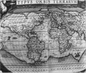
As shown in the map below, Ortelius in 1570 divided the Atlantic into two distinct basins, labeling the northern one “Mar Del Nort” (North Sea) and the southern one “Ethiopian Ocean.” He identified the Indian Ocean as a single basin, called simply the “Sea of India,” and designated the Pacific as the “Mar Del Sur”. The result was a map showing four major oceanic basins: the North Atlantic, the South Atlantic, the Pacific, and the Indian. This scheme is remarkably similar to the modern-day maritime classification, the only major difference, other than that of nomenclature, being the division of the Atlantic.
The map displayed directly below on the right is taken from A new voyage and description of the Isthmus of America, a report by the Welsh explorer Lionel Wafer[3]. The map first appeared somewhere between 1695 and 1699, and is one the earlier recorded maps to use the phrase “South Sea”. As is evident from the image, the South Sea is simply labeled as the area not encompassed by the Bay of Panama. These specific maps were chosen due to the likelihood of their being utilized by the Company’s proprietors, as they were all published before the creation of the Company’s charter.
Similarly, another influential map was published in 1705 by William Dampier.[4] Reproduced below on the left, the nomenclature of the “South Sea” is used to delineate a geographically ambiguous area. This pattern continued to be propagated through the charter of the South Sea Company, written in 1711. While this particular map pays great attention to smaller bodies of water as well as coastal areas, the South Sea is left undefined and we must assume that it extends to the whole of the ocean.
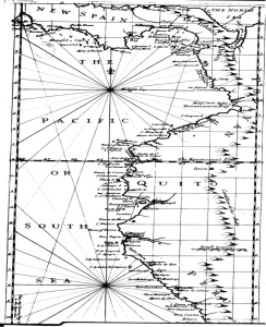
One additional map, pictured on the right below this paragraph, was particularly influential in how the delineation of the oceanic nomenclature was incorporated into the writing of the South Sea Company Charter[5]. Published in 1709, it labels the ocean as both the Pacific as well as the South Sea. This map, along with the previously discussed maps, shows how the South Sea’s boundaries were poorly defined and minimally understood. The author seems to be undecided as to the correct name of the ocean, and simply decides to utilize both. This is particularly odd in this specific map because of the way it seems to focus on the sea. With the exception of the South and Central American coasts, the interior geography is left ambiguous. Through the writing of the South Sea Company’s charter, the boundaries of the South Sea remained undefined.
As evidenced by the previous maps and discussion, the South Sea was a term often substituted for the term Pacific Ocean, but one that held little real-world specificity. It seems odd, then, that the South Sea Company, chartered in 1711, did not specify where its claims to corporate sovereignty would extend.
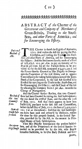
The South Sea Company Charter reads in part “into unto and from the Kingdoms, Lands etc. of America, on the east side of the river Aranoca, to the southernmost part of the Terra del Fuego, on the west side thereof, from the said southernmost part through the South Seas to the northernmost part of America…”[6]. The land boundaries are relatively well delineated, and clearly encompass the vast majority of South America. The river Aranoca does not directly correspond to any modern river, but in the below map it is shown to be at the northeast corner of the continent, and Terra del Fuego is an island at the southern tip of the continent. The charter is certainly more concerned with geographic accuracy on land than on sea.
The charter is a quite specific document in terms of the company’s structure, as it sets up a board of directors and the rights of stockholders in definite terms. In fact, the majority of the document is focused on rules concerning this Court of Directors. The company’s organization is clear and organized, a testament to the intention of the founders to create a viable corporation. Interestingly, the charter lays claim to all “Islands, Forts, Places and Mines” within its boundaries, as well as all trade, including ships found within its territory. These extensive claims stand in stark contrast to the vague claims over the sea, leading to the possibility that the company’s oceanic boundaries were left intentionally vague, in order to maximize the rights that the ships sailing the South Sea could justifiably exercise.
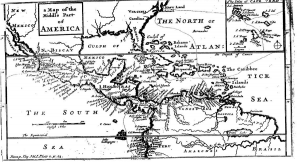
As a final piece of evidence, the following map by Herman Moll was created after the Company’s charter was written, and specifically set out to map the company’s boundaries. Yet even this map does not specify what portion of the ocean is claimed by the Company.
As evidenced by the previously cited maps, the type of sovereignty that we looked at was quite different from that of the other groups in this project. In particular, we focused on an inherently more fluid area of the globe, and as such sovereignty looks quite different in water than it does on land. The boundaries of the ocean seem to have been changing constantly and were challenging to map, which certainly plays a part in the non-specificity of the cited maps[7]. While boundaries on land are quite fluent, as shown in the other case studies, the ocean poses unique challenges to those attempting to map sovereignty. The South Sea Company Charter did not lay out an exact or definite piece of geography as solely its own, an anomaly among the charters catalogued in our project.
Why would the South Sea Company not specifically define the ‘South Sea’? As shown by the previous maps of the world, the South Sea had no commonly accepted boundaries. The writers of the company’s charter were content to claim sovereignty over this vast, undefined area. As argued by other projects chronicled on this website, the fluidity of sovereignty can be seen through this phenomenon. While the charter purports to claim power over the entire South Sea, the vague, inconsistent and inaccurate rendering of this area was an important omission. If the authors ever truly intended to trade in or control such a vast area, the area would have been clearly and unarguably defined. The authors knew that their charter would have little impact on the seas, and chose not to attempt to hide this reality. The inability to claim the sea was an instrumental part of the eventual collapse of the company.
[1] C. R. Markham, ‘Vasco Nuftez de Balboa, 1513-1913’, Geographical Journal, XLI(1913), 517-32 at 519; K. Romoli, Balboa of Darien (New York 1953), 165-8; J. Mirsky, The Westwards Crossings, 2nd ed. (Chicago 1970), 60-1; J. T. Medina, El Descubrimiento del Oceano Pacifico (Santiago de Chile 1913-20), I, 87 and III, cclxviii.
[2] ‘South Sea’ to ‘Pacific Ocean’: A Note on NomenclatureAuthor(s): O. H. K. SpateSource: The Journal of Pacific History, Vol. 12, No. 4 (1977), pp. 210
[3] Wafer, Lionel, 1660?-1705?. A New Voyage and Description of the Isthmus of America, Giving an Account of the Author’s Abode there Electronic Resource] : The Form and make of the Country, the Coasts, Hills, Rivers, &c. Woods, Soil, Weather, &c. Trees, Fruit, Beasts, Birds, Fish, &c : The Indian Inhabitants, their Features, Complexion, &c. their Manners, Customs, Employments, Marriages, Feasts, Hunting, Computation, Language, etc. : With Remarkable Occurrences in the South Sea and Elsewhere. London: Printed for James Knapton .., 1699. Web.
[4] Dampier, William, 1652-1715. Voyages and Descriptions. Vol. II Electronic Resource] : In Three Parts : To which is Added a General Index to both Volumes. London: Printed for James Knapton, 1700. Web. Pp. 40
[5] Rogers, Woodes. A cruising voyage round the world: first to the South-Sea, thence to the East-Indies, and homewards by the Cape of Good Hope. Begun in 1708, and finish’d in 1711. … With maps … By Captain Woodes Rogers, … The second edition, corrected. London, 1726. Eighteenth Century Collections Online. Gale. Duke. P 452 University Library – Perkins. 12 Apr. 2014
[6] Great Britain. An abstract of the several acts of Parliament, commission for taking subscriptions, charter, and by-laws of the honourable South-sea company. [London?] Collected and printed by R. Mount, 1718. The Making Of The Modern World. Web. 21 Feb. 2014.
[7]”The Pacific Ocean: 250 Years of Maps (1540–1789).” Strait Through: Magellan to Cook & the Pacific. Ed. John Delaney. Princeton University Library, n.d. Web. 1 May 2014. <https://libweb5.princeton.edu/visual_materials/maps/websites/pacific/pacific-ocean/pacific-ocean-maps.html>.
